Disclaimer
This article is based on publicly available resource consent documents, property file material, submitted plans, and published marketing content, alongside site observations and independent analysis.
It reflects the author’s interpretation of the material as presented at the time of writing and is intended as commentary, not professional planning, engineering, or legal advice.
Some documents referenced were obtained via official information requests. Personal contact details and private correspondence have been excluded or summarized where relevant.

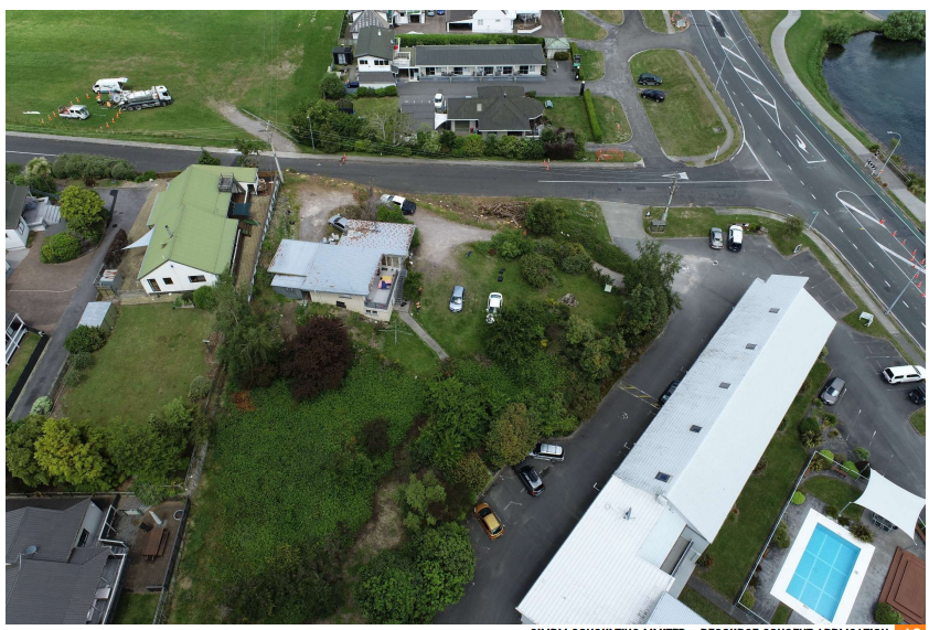
Credit: Google maps
Why I’m Writing This
I’ve sat with the Two Mile Terraces property file for several days now.
Not skimmed it.
Not cherry-picked a page or two.
I read it front to back, sideways, upside down — all 662 pages of it. The full file weighs in at 544MB, which should tell you something before you even open it.
I’m not a neighboring landowner.
I don’t have a personal axe to grind.
What I do have is a working understanding of how land, buildings, slope, and people interact — and enough patience to actually read what’s been lodged with Council, rather than relying on marketing blurbs.
This post is not about feelings.
It’s about what the documents actually show.

Site extent for the proposed Two Mile Terraces development (from planning documentation)
Image source: Applicant planning documentation lodged with Taupō District Council (RM250145).
What Is Two Mile Terraces?
Two Mile Terraces is described as a medium-density residential development proposed for Two Mile Bay, Taupō, spanning:
- 4 Hawai Street
- 284 & 288 Lake Terrace
Public-facing marketing currently focuses on 17 “luxury” townhouses, promoted by Bayleys (the sole real estate agent for the site).
However and this is the first important point — the planning documentation describes a larger, staged development across the full site.
That distinction matters.
Under the Resource Management Act, effects are assessed on the whole proposal, not just the portion currently being advertised or sold.
You don’t get to assess 17 units if the consent enables 30-plus.

Overall development massing as presented in applicant materials
Image source: Applicant planning documentation lodged with Taupō District Council (RM250145).
What’s in the Property File (and Why It’s Not Light Reading)
The property file contains:
- Historical planning records going back years
- Multiple amended site layouts and elevations
- Several design iterations
- Detailed geotechnical investigations
- Council Requests for Further Information (RFIs)
- Technical responses from consultants
- Updated plans uploaded well after initial neighbour concerns were raised
This isn’t a neat, linear story. It’s a moving target; revised, adjusted, reduced in places, and expanded in others.
Which leads to the first core issue.
Issue 1: Medium Density on Paper, High Density in Reality
The development is labelled “medium density”.
But when you look at:
- the number of units
- the scale of built form
- the near-continuous building mass along boundaries
- the reliance on balconies as primary outdoor space
- the minimal usable ground-level living areas
…it starts behaving like high density dressed up in a medium-density outfit.
Yes, the updated figures state:
- ~19.3% site coverage
- ~40.5% plot ratio
Those numbers sound comforting. But they don’t describe how the buildings actually sit on the land.
Density isn’t just math.
It’s massing, height, proximity, and lived experience.

Photo credit Image source: Applicant planning documentation lodged with Taupō District Council (RM250145).
Issue 2: Bulk, Height, and Boundary Effects Are the Real Story
One of the most consistent threads in the file relates to boundary effects, particularly along Hawai Street.
Key points pulled directly from the documentation and correspondence:
- Early iterations proposed earthworks cuts up to 5.5 meters along boundaries
- This was later reduced, but only after Council requested further information
- Retaining structures are acknowledged as high risk and dependent on final design
- Detailed construction methodology is explicitly deferred to later stages
In plain English:
The hardest, riskiest parts of the project are still being waved through with “we’ll sort that later”.
That’s not unusual in development, but it is relevant when assessing effects on neighbors and the stability of the site itself.


View from the deck at 10 Hawai Street. Dashed line shows maximum permitted height. Solid line shows proposed building height directly in front of the primary outdoor living area. Image source: Applicant planning documentation lodged with Taupō District Council (RM250145).
Top image : 3D boundary massing model showing the relative siting and scale of proposed development blocks in relation to neighboring properties at 8 and 10 Hawai Street (as presented in consent documentation). Image source: Applicant planning documentation lodged with Taupō District Council (RM250145).
Issue 3: Geotechnical Reality — This Is Pumice, Not a Blank Slate
The geotechnical report (from page ~257 onwards in the file) confirms what locals already know:
- The site sits on pumice and volcanic sands
- Soil profiles vary across short distances
- Stability is highly dependent on how and where cuts are made
Pumice behaves very differently from dense clay or rock.
Once you start scraping, cutting, and retaining, especially near boundaries — movement becomes a real consideration, not a theoretical one.
The report repeatedly relies on future detailed design, future supervision, and future certification.
That may satisfy minimum process requirements, but it doesn’t magically remove risk.


Click for bigger photos : This matters because tall, heavy structures behave very differently on this kind of ground. Image source: Applicant planning documentation lodged with Taupō District Council (RM250145).
Issue 4: Living Space vs. “Luxury”
This is where the word luxury starts to wobble.
From the plans:
- Many units rely on balconies as their primary outdoor living space.
- There is very limited usable garden or ground-level outdoor area.
- Storage, furniture, bikes, extra vehicles — all the normal stuff people actually own — are barely accounted for.
People don’t live as diagrams.


Click for bigger photo – Photo credit Abode Residential website
They have:
- more than one car
- outdoor furniture
- hobbies
- guests
- children
- visitors who don’t arrive on bicycles
Calling something “luxury” doesn’t make it so.
It has to function like a place people actually want to live long-term.

Photo credit Abode Residential website
Issue 5: The Site and the Buildings Don’t Talk to Each Other
One of the most striking things, once you step back from the numbers, is this:
There is no real conversation between the land and the buildings.
The development doesn’t feel shaped by the slope.
It feels placed onto it — then engineered into submission.
There’s no clear hierarchy.
No breathing room.
No sense of the buildings stepping with the terrain in a way that feels settled or resolved.
Instead, the site reads as:
“Here’s the form we want. Now make the land comply.”
That approach always shows.
And it shows most clearly in elevated, highly visible locations like Two Mile Bay — where landform, outlook, and silhouette matter just as much as yield and unit count.
When buildings respond to land, they belong.
When land is forced to serve a pre-set form, the result is tension, expressed through excessive earthworks, dominant retaining structures, and architecture that feels imposed rather than anchored.
This proposal falls into the latter category.


Issue 6: What the Marketing Emphasizes — and What It Doesn’t


The marketing material is not inaccurate, but it is selective.
It presents the project through lifestyle imagery and premium positioning, while downplaying the physical and technical realities that shape how the development actually functions on site.
Marketing highlights:
- views and outlooks
- proximity to the lake and local amenities
- lifestyle-led imagery
- a curated portion of the development experience
The property file shows:
- overall scale and massing across the full site
- cumulative bulk and boundary proximity
- impacts on neighbouring properties
- staged intensity rather than a single, resolved form
- reliance on technical solutions still to be worked through
Both can be technically true — but they are not the same story.
And when only one of those stories is front-facing, people are entitled to ask questions.
Why This Matters (Even If You’re Not a Neighbour)
This isn’t about stopping development.
It’s about getting the right development in the right place, done honestly.
Two Mile Bay is not Auckland.
Taupō has different land, different scale, different expectations.
When a project pushes right up against what’s permitted — and then relies on technical deferrals to make it work — scrutiny isn’t obstruction. It’s common sense.

Photo credit Taupo 2 mile bay sailing club
Stay tuned for part 2.
Taupō District Council
- Resource Consent Application RM250145 – 4 Hawai Street / 284–288 Lake Terrace, Two Mile Bay
- Property file documents accessed via Taupō District Council
- Section 92 Request for Further Information correspondence
- Planner correspondence (Kim Smillie, Intermediate Resource Consents Planner)
- Development Engineering site visit notes (as referenced in council correspondence)
Survey & Site Information
- Kotare Consultants
- Topographical Survey of Proposed Development Site
- Existing buildings, contours, site boundaries, and service overlays
- LINZ cadastral data (as referenced in survey documentation)
Geotechnical
- Hight Consulting Engineers
- Geotechnical Investigation Report
- Hand auger logs (HA1, HA2)
- Borehole logs and soil profile photographs
- Soil classification and bearing capacity data
Architectural & Development Drawings
- Abode Residential Limited
- Overall site layout plans
- Block layout and apartment distribution plans
- Coverage and plot ratio calculations
- Height envelope and boundary compliance diagrams
- Project Zero / Strata Architects / MHL Studios
- Architectural drawings and renders (as submitted with the consent application)
Marketing & Sales Material
- Bayleys Real Estate
- “Two Mile Terraces” website listing and promotional copy
- Rendered images and pricing information
- Developer website marketing material for Two Mile Terraces
Visual Material Used for Analysis
- Council-submitted renders showing boundary relationships (8 & 10 Hawai Street)
- 3D massing and height comparison imagery included in the consent file
- Current photographs of outlook from 10 Hawai Street (website)
Author’s Observations
Independent analysis comparing consent documentation, survey data, and marketing material.


Leave a Reply